UNIT TWO - THE NATURE OF REAL PROPERTY
Land Description (Cont.)
Rectangular Survey System —
The rectangular survey system also is called the section and township system or U.S. government survey system.
This is the method used by the U.S. Surveyor General to survey public lands. This system bases descriptions of land on its distance from a base line that runs east-west and a meridian that runs north-south from a reference point.
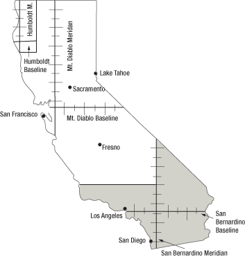
FIGURE 2.6 —
California Township and Range Survey System
The map in Figure 2.6 shows the three principal baselines and meridians used in California land descriptions. The Humboldt Baseline and Meridian were established on Mt. Pierre in Humboldt County in 1853; the Mt. Diablo Baseline and Meridian were established on Mt. Diablo in Contra Costa County in 1851; and the San Bernardino Baseline and Meridian were established on San Bernardino Mountain in San Bernardino County in 1852. A parcel may be described using different reference points.
For example, property in the City of Fresno, as shown in Figure 2.6, may be described as ____ miles South and ____ miles East of the Mt. Diablo Baseline and Meridian, or as ____ miles North and ____ miles West of the San Bernardino Baseline and Meridian.
Land division —
Land area is divided into townships that are measured and numbered in each direction from the point of intersection of the baseline and the meridian. A township does not refer to a town or community; instead, it is an area of six miles square (36 square miles).
Because of the curvature of the earth, the lines that set off each township are not perfectly parallel, and there must be some way to compensate for this. Every four townships north and south of the baseline, a correction line is measured at the full interval (six miles) for that side of each township it borders. Every four townships east and west of the principal meridian, a guide meridian establishes the full interval of six miles for that side of each township it borders. This is illustrated in Figure 2.7.
Townships run north-south in groups called tiers (think of the tiers of a wedding cake) and east-west in groups called ranges (think of a vertical slice of cake layers). The township identified as T2N, R3E is the township in the second tier north of the baseline and the third range east of the meridian. It is highlighted in Figure 2.7.
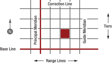
FIGURE 2.7 —
Townships